Neighborhoods

Exploring the Southwest Hills Neighborhood by Lee McKnight

Screen Shot 2020-01-16 at 4.27.44 PM.png

History

In the late 1880s, lots in the area we now call the Southwest Hills were going for $250. The Portland Cable Railway Company, formed in 1887, planned to hit it big with its cable car line that would open up the hills for residential development. The track took passengers from Union Station along SW 5th to SW Jefferson and over to SW 18th (formerly Chapman St), where it began the significant climb up to Elizabeth Street.

There were a couple of accidents involving runaway cable cars early on, and the Railway Company went under as a result of overzealous expansion into other residential areas. The cable car line was ultimately purchased by the bank and incorporated, so that cable car service would continue. The Portland Traction Company took over the route, converting it to electric in the 1890s. Rail lines spurred early development, but the area blossomed as a residential destination alongside the popularization of the automobile.

The neighborhood was always a destination for the affluent both because building and living in it required more significant means, and because it was considered a respite from the smoke and dust of the city’s industrial development along the Willamette River.

An electric railway route to Council Crest, the highest peak in Portland, was constructed around the time of the 1905 Lewis and Clark Expo. The journey to the 1700 ft peak was popular with residents and tourists. On a clear day, the view at the top included five mountains in the Cascade Range: Mt Hood, Mt Adams, Mt St Helens, Mt Jefferson, and Mt Rainier. The park has a colorful history, including a stint as an amusement park, and has always been a treasured place in Portland. Railway service to the park ran until about 1950.

Residential development in the Southwest Hills has continued throughout the decades resulting in a diversity of architectural styles including ranch, colonial, craftsman, contemporary, and a handful of Victorians. There are numerous high-end residential properties, including some notable historic residences like the Frank J. Cobbs House, designed by renowned Portland architect George D. Mason. The hills also have some multi-family properties, including condos, townhouses, and apartment buildings.

The area has remained primarily residential and is a favorite neighborhood and destination for those Portlanders who enjoy hiking, trail running, and mountain biking.

Amenities

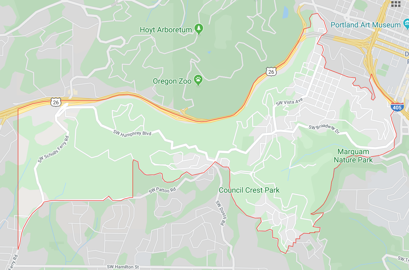
The curvy boundaries of the Southwest Hills mirror the winding streets throughout this mostly residential neighborhood. The Northeastern bordery is a combination of a stretch of the I-405, the full length of SW Cardinell Drive, and a couple other turns and twists along SW Vista until it connects with Highway 26, which marks the entire northern edge of the neighborhood.

The western edge of the neighborhood is just shy of Highway 8, and the southern boundary winds along SW Scholls Ferry Road, SW Patton, SW Fairmount Blvd, before it cuts northeast through the Marquam Nature Park to SW Terwilliger and meets with the I-405. Residents have easy access to both highways and great proximity to downtown Portland and OHSU.

Ainsworth Elementary is the only school within the neighborhood boundary. The nearest Portland Public Schools for middle school and high school are West Sylvan Middle School, and Lincoln High School.

Points of Interest

The parks are the stars of the Southwest Hills neighborhood. Council Crest Park has attracted visitors and residents alike. An amusement park (aka Dreamland of the Northwest) was operational atop this peak from 1907 to 1921. Only one remnant of the park remains today; the Water Tower used to be a 70-foot tall observatory. The rest of the park was demolished in the 1940s. Council Crest Park is accessible via car, on foot along one of the many residential streets that lead to it or the popular Marquam Trail.

Marquam Nature Park is another treasured respite in the neighborhood. The northwestern part of the 178-acre Park is within the neighborhood boundary. In the 1960s, developers were planning to build a 600-unit apartment complex in the Marquam Ravine. Residents of the neighborhoods around the natural area came together to fight the development and preserve the land for public use. The group incorporated as Friends of Marquam Nature Park. Portland Parks & Recreation took over the park in 1979 and continue to manage it in partnership with volunteers from Friends of Marquam Nature Park.

Another notable park in the neighborhood is Portland Heights Park. At nearly 5.5 acres, the property boasts a play structure, picnic areas, tennis and basketball courts, a softball diamond, and a soccer field. Situated near the center of the neighborhood, along SW Patton road, the park is just a few blocks away from the Marquam Trail that connects Council Crest Park to Washington Park on the other side of Highway 26.

Culture

There is little in the way of commercial activity, the sole restaurant in the neighborhood at this time is long-standing Vista Spring Cafe. The cafe is in the northeastern quadrant of the community, across the street from Ainsworth Elementary, and is a family-friendly spot offering pizzas, hamburgers, and salads.

The only grocery store in the neighborhood (Strohecker’s), formerly located on SW Patton, closed a couple of years ago. The neighborhood association is keeping tabs on proposed plans for the property. Current details are available here (scroll down a bit).

The Southwest Hills is a quiet, residential neighborhood where many properties appear to be peeking out from a never-ending swath of greenery. Outdoor enthusiasts will feel right at home in this area where they can walk to some of Portland’s most popular trails (i.e., Marquam and Wildwood). Easy access to Washington Park–home to the Japanese Gardens, International Rose Test Garden, Hoyt Arboretum, Portland Children’s Museum, World Forestry Center, and the Oregon Zoo–just on the other side of Highway 26, the northern boundary, is also a huge perk.


Southwest Hills at a Glance

Southwest Hills Neighborhood Boundary Map

Southwest Hills Residential League (neighborhood association)

Southwest Neighborhoods, Inc (coalition of 17 southwest neighborhoods)

Southwest Hills Census Data (2000, 2010)

Exploring the Montavilla Neighborhood by Lee McKnight

Montavilla Boundary Map.png

Sometimes nicknames stick. Montavilla, formerly Mount Tabor Villa Addition, got its name from the abbreviation used on signs for the streetcar stop–Mt. Ta. Villa–which evolved to Montavilla, the name we use today. In the early days, over 130 years ago, Montavilla was a small farming community. Construction of the Morrison Bridge in 1887 made East Portland more appealing and more accessible, opening the door for residential development in neighborhoods like Montavilla.

The 1890s saw commercial development too, with a few grocery stores and meat markets, a bank, a post office, and a streetcar stop along the extended Ankeny line. Residents could access jobs in downtown Portland via the streetcar, and investors and developers took note of the area’s changing status. By 1914, Montavilla was considered a prosperous suburb.

Continued prosperity led to further residential and commercial development. Although Montavilla experienced a decline in the 1970s and 80s along with the rest of Portland, it bounced back beginning in the 1990s with anchors like the Flying Pie Pizzeria, the BiPartisan Cafe and the Academy Theater–renovated in 2006.

The neighborhood still has many older buildings, both commercial and residential, and there is currently a project underway to document historical buildings on a portion of the central commercial district. Graduate students from the University of Oregon’s Historic Preservation Program will review and record all historic buildings along SE Stark between SE 76th and 85th and SE Washington between SE 80th and 84th.

Montavilla has an active Neighborhood Association that is committed to ensuring that the perspectives of all residents are considered in neighborhood plans like proposed zoning changes, maintaining diversity, and supporting local schools. Residents have formed groups around various shared interests–gardening, pets, crafting, and even emergency preparedness–as a way to develop community and help neighbors get to know one another.

A big part of the appeal of Montavilla is that it feels like a town within a city where residents can get most of their basic needs met locally. Residents value community and appreciate friendly neighbors–wander down any residential street, and you’re likely to see evidence of neighborliness like the numerous little libraries in front of homes.

Amenities

Montavilla’s boundaries are I-84 to the north, I-205 to the east, SE Division to the south, and it’s western edge runs from NE 68th and then doglegs on Burnside over to SE 76th Ave. The neighborhood is well-positioned for commuters given ready access to both I-84 and I-205.

There is one elementary school in Montavilla, Vestal Elementary (K-5), three elementary/middle schools Creative Science School (K-8), Harrison Park School (K-8), and Bridger School (K-8). The closest high school is Franklin High School in South Tabor. Portland Community College’s Southeast Campus is located at the neighborhood’s southern boundary.

POINTS OF INTEREST

While Montavilla residents have excellent access to the expansive, 190-acre, Mt Tabor Park in the adjacent Mt Tabor neighborhood, they also have a lovely park of their own. Established in 1921, Montavilla Park covers nearly 10-acres. The park has play structures, picnic areas, and paved paths. In 2014, the Portland Timbers sponsored the construction of a futsal field within the park.

CULTURE

In the 1890s, when Montavilla was just a collection of small farm sites, there was a little business district clustered around what was known as the P5 marker. The P5 marker, erected in 1854, on Baseline Road (now SE Stark Street) at SE 78th Avenue, indicated a five-mile distance to downtown Portland. The commercial heart of this neighborhood still hovers around this same area.

A wonderful mix of vintage shops, services, restaurants, and watering holes, Lonely Planet voted Montavilla one of the best neighborhoods in the country a few years ago. There are a handful of long-standing business anchors like Flying Pie Pizzeria opened 35 years ago in Montavilla, beloved Lebanese restaurant YaHala that opened in 1999, and BiPartisan Cafe, the neighborhood fixture for coffee and pie since 2004.

The Academy Theater that opened on SE Stark in 1948 underwent renovations in 2006 after being used as an office building through the 1970s. Now it shows second run and classic films. There is plenty of nightlife around the theater, including extensive tap lists to explore at Roscoe’s and Beer Bunker, and craft cocktails at the slightly swanky Vintage Cocktail Lounge.

A handful of small boutiques and vintage shops keep this commercial corridor active during the daytime too. Union Rose retails locally made wares, Cactus Records thrift store sells an assortment of vintage goods including records, and Monticello Antique Market stocks vintage goods from over 100 vendors. Former food cart Hungry Heart Bakery opened a few years ago just off the main drag on SE 80th serving breakfast and lunch along with hand-crafted pastries and coffee.

Five blocks north, on NE Glisan, there are a few popular spots for food and drink, including thin-crust-focused East Glisan Pizza Lounge, and Vietnamese classic Hanoi Kitchen. A few years ago, German bread and pastry wizards Fressen Bakery, took over a space on NE Glisan when they relocated from Sullivan’s Gulch to Montavilla.

Exploring the King Neighborhood by Lee McKnight

King is one of the most popular neighborhoods in Northeast Portland. Centrally located with a high walkability score and easy access to public transit and commuter routes, King also has a variety of home styles, including Craftsman, Victorian, and new construction. King has changed significantly since the City of Portland declared it part of a blighted area in the 1980s. Driving the stretch of ME MLK Blvd that is the neighborhood’s main commercial corridor, you will also see evidence of substantial commercial development.

The story of the King neighborhood is the story of racism against black people* in Portland, and the resulting disparity and gentrification. Originally part of the city of Albina, until Portland annexed it in 1891, the King neighborhood went by the name Highland until 1989 when its main commercial corridor–Union Avenue–was renamed Martin Luther King Junior Boulevard. The neighborhood followed suit and renamed itself King.

King is part of what is known as the Albina area or Albina District, which includes Eliot, Boise, Humboldt, Overlook, Irvington and Piedmont neighborhoods. Early residents of the city of Albina–which was platted in 1873–were Irish, German, and Russian immigrants who came to work for the railroads. When the city was annexed by Portland nearly two decades later, west side residents fleeing overcrowded residential areas–especially African American residents who were restricted to specific areas on the west side–moved east.

Throughout the early 1900s, especially during World War II, the neighborhood grew given its proximity to jobs–primarily railroad and shipbuilding–and decent public transportation via streetcar. After the war, European immigrants moved to other neighborhoods. Portland’s black residents remained. Discriminatory real estate practices from the 1940s through the 1970s kept Portland’s black residents concentrated in the Albina district neighborhoods. There was a vibrant black business community in the 1950s. Still, little support from the city for urban renewal projects and redlining blocked access to capital, so the neighborhood declined throughout the 60s and 70s.

The construction of the Memorial Coliseum, I-5 corridor, and the Emmanuel Hospital complex removed a significant amount of housing and displaced hundreds of residents from the neighboring Eliot community. Businesses and residents moved north into the King neighborhood, which became the center of Portland’s black population. Continued discrimination and predatory lending practices led to the area becoming blighted in the 80s. In the 90s, the City of Portland decided to invest in and revitalize the area.

Considerable development, both commercial and residential continues in King. The Neighborhood Association is active in working to maintain the neighborhood’s livability, as is evidenced by its efforts to create safe cycling corridors, ample green space, and to demand cleanliness and safety from commercial tenants.

*Interested in learning more? Check out this essay in the Oregon Encyclopedia online archives, “Blacks in Oregon,” by Dr. Darrell Millner, former Department Chair of Black Studies from 1984-1995 at Portland State University and current Professor Emeritus and adjunct faculty member. Priced Out (2017)and its precursor, Northeast Passage: The Inner City and the American Dream (2002) are documentaries specifically about the history and gentrification of the Albina District. And, of course, there’s a Priced Out podcast too.

amenities

No matter how you plan to get around in Portland, the King neighborhood is well situated for commuting. Residents are approximately one mile east of I-5 and just a few blocks from cycling corridors (N Vancouver and N Williams). Numerous bus routes service the neighborhood along NE MLK Blvd, NE Alberta, NE Prescott, and NE Killingsworth.

Dr. Martin Luther King Junior Elementary School is within the neighborhood boundary. The closest middle schools are Harriet Tubman Middle School in Eliot, Ockley Green Middle School in Arbor Lodge, and Beaumont Middle School in Beaumont. Jefferson High School in neighboring Boise is the nearest high school.

King School Park is at the heart of the neighborhood. The adjacent parking lot is the location of the seasonal King Farmers Market that runs from May through November. The park has basketball courts, soccer fields, a track, and play structures.

Completed in 2001, Two Plum Park is a postage stamp-sized (.36 acres) park located in the southern part of the neighborhood. The park grounds used to be a couple of vacant residential lots. One of the lots was cleared of debris and cleaned up by frustrated area residents around the same time that Portland Parks & Recreation allocated funds received from a foundation to create more parks. PR&R was able to purchase both lots to establish the park. PR&R invited Neighborhood residents to collaborate on the design of the park.

culture

Whether you’re interested in Ethiopian food, Pacific Northwest cuisine, or classic pub fare, the King neighborhood has you covered. And all of it is easily explored on foot, bicycle or bus!

Over the past ten years, a flurry of restaurants have opened at the southern end of NE MLK Blvd beginning with wood-fire focused Ned Ludd in 2008, family-owned Sengatera Ethiopian (this is their second location, the first being in the Sengatera neighborhood of Adis Ababa!) and market stand turned brick-and-mortar bakery Bushel and Peck in 2012. This part of MLK is also home to The Community Warehouse, a furniture bank collecting furniture and household goods to distribute–with help from various social services agencies–to those in need. If you love browsing vintage goods, check out the Estate Shop adjacent to the warehouse.

Further north along MLK is Mama Pauline’s African Market where you can find African snacks, fabric, food stuffs, and beauty products. Just around the corner from Mama Pauline’s is the Portland Playhouse, a local theater that started putting up plays in an abandoned neighborhood church in 2008. Read their story about getting the church approved for a new use to see what’s possible when citizens band together to support the arts.

The intersection of NE MLK and NE Alberta underwent major commercial construction in the past few years and is now home to a gym, a new grocery store, and Cason’s Meats–a butcher shop that relocated from the historic Kenton neighborhood. The stretch of NE Alberta between NE MLK and NE 14th Street has experienced steadily increasing commercial growth since the early aughts.

When the Tin Shed Cafe opened in 2003, few guests of the restaurant would have been compelled to head east on NE Alberta because there wasn’t much in terms of retail businesses to explore. In the last ten years, this has changed dramatically, businesses that have opened include an upscale fabric and sewing store, a snug Swiss restaurant, a vegan bar, a reimagined neighborhood pub, and a tiny house hotel.

Exploring the Hayden Island Neighborhood by Lee McKnight

Screen Shot 2019-10-20 at 8.04.12 AM.png

Image Canoe, Menzies, and Shaw are a few of the names Hayden Island had before its current moniker stuck. The island, located in the Columbia River–just before its confluence with the Willamette River–was originally discovered in 1792 by the Royal Navy. The ship’s lieutenant named the island after the expedition’s botanist, and then Lewis and Clark floated along nearly a decade later and called it something else entirely. And so it went for Hayden Island until the arrival of an early Vancouver, Washington settler by the name of Gay Hayden. He settled on the island in 1851 when he heard about the Donation Land Claims Act. Hayden built a home on the island and lived there for about five years with his wife and two children.

Originally, all transport to the island was by boat. A ferry service ran between Vancouver and Hayden Island before construction of the first Interstate Bridge in 1917. Once the bridge was built, streetcar service ran from Hayden Island largely to service the booming amusement park developments that took over the eastern part of the island.

The island was home to the Jantzen Beach Amusement Park, the largest amusement park in the nation at its opening in 1928. Three-quarters of a million people visited the park each year during its heyday to enjoy the roller coaster, train rides, swimming pool, and carousel. Tomahawk Island, just east of Hayden Island, was the site of an amusement park competitor, Lotus Isle.

Lotus Isle was short lived and rife with tragedies. The park opened in June of 1930 with over 40 attractions on its beachfront acreage. A couple of months after it opened, a young boy drowned and died. The park owner committed suicide the next day. The park’s new manager hosted a successful Dance-A-Thon event in the massive ballroom (could hold 6600 dancers!). The following season, a frightened elephant stampeded through the grounds destroying several pavilions and a devastating fire burned the ballroom to the ground. The park operated one final season in 1932 before declaring bankruptcy and liquidation.

Jantzen Beach Amusement continued to thrive until the 1960s when attendance started to decline. The park closed permanently in 1970 and construction on the Jantzen Beach Mall began the following year. Mall developers decided to honor the history of the location by incorporating the carousel into the design of the property. In 2012, developers redesigned the mall for the second time and their updated strip mall layout did not include a home for the carousel. Local preservationists fought for Portland to keep and restore the carousel for its craftsmanship and historical significance. The carousel has been restored but its advocates are still seeking a home for it in Portland.

In the late 1950s, the Interstate Bridge was upgraded and incorporated into the I-5 freeway. The only thing that physically connects Hayden Island to Oregon is the state’s northernmost I-5 exit. Tomahawk Island was connected to Hayden Island using materials excavated during the I-5 construction. The joined landmasses are now commonly referred to as Hayden Island and the eastern area (formerly Tomahawk) is where most of the island’s residential developments are, including the floating home communities.

The Jantzen Beach Shopping Center is just west of I-5 as are the island’s mobile home parks. Just beyond the shopping mall is the railway bridge connecting commercial and passenger rail service between Oregon and Washington. Beyond the railway bridge is approximately 800 acres of land that the Port of Portland purchased from Portland General Electric with plans to construct additional Marine terminals. Local environmentalists and residents successfully lobbied to maintain the 800 acres as a preserve. The land is not accessible to the public, except by boat.

AMENITIES

Residents of Hayden Island are close to both downtown Portland and Vancouver via the I-5 corridor. There is also unrivaled access to the riverfront and Columbia River Gorge Recreation areas.

There are no schools on the Island. Portland Public Schools places elementary and middle school children at Faubion School, and high school kids can choose between Jefferson High or Roosevelt High.

There is one small park, Lotus Isle Park on the eastern part of the island. Here you will find a play structure and a paved pathway offering views of the water and the streetcar trestle that used to connect Hayden and Tomahawk Islands.

culture

Hayden Island is known to most Portlanders as the location of the Jantzen Beach Shopping Center. Those with boats may also know it as their point of departure for river adventures. This is a relatively quiet and tight-knit residential community rather than a raucous waterfront hangout. Residents can boat, kayak and canoe easily- often from their backyards.

The island is home to two yacht clubs, the Corinthian and Columbia River Yacht Club, and multiple marinas. If you’ve always wanted to sail, but don’t know how, Island Sailing School & Club might be the perfect place to learn.

Shopping and dining options are concentrated at the Jantzen Beach Center and largely national chains. There are some exceptions like the taco truck just off the northbound I-5 exit, and the seasonal Island Cafe which is open from April through September.